LiDAR-Based Topographic Detection for Mining Area Exploration
- Introduction
Mining exploration is a crucial initial stage in determining the presence and potential of mineral resources in a given area. The success of exploration is heavily influenced by the quality of the data used, particularly topographic data. Accurate topographic information is necessary to understand surface conditions, such as landforms, slope gradients, and geological structures that play a role in the formation of mineral deposition.
Conventional mapping methods such as terrestrial surveys and photogrammetry are still generally used. However, these methods have various limitations, including being time-consuming, costly, and having difficulty reaching hard-to-access areas. Furthermore, in areas with dense vegetation cover, such as in Indonesia, conventional methods often struggle to obtain accurate ground surface data due to obstruction by the vegetation canopy.
With the advancement of geospatial technologies, LiDAR (Light Detection and Ranging) has become a reliable solution for high-resolution topographic mapping. LiDAR utilizes laser pulses to measure distances between the sensor and the Earth’s surface, producing highly accurate three-dimensional data (Chen et al., 2017). In Indonesia, the application of LiDAR continues to grow, particularly in national mapping and natural resource exploration supported by the Badan Informasi Geospasial (BIG, 2018). Therefore, LiDAR plays a key role in improving the efficiency and accuracy of mining exploration.
- How LiDAR Works
LiDAR operates on the principle of distance measurement using laser pulses emitted from the sensor toward the Earth’s surface. LiDAR sensors are typically mounted on platforms such as airplanes, helicopters, or drones (UAVs). When a laser pulse strikes an object on the Earth’s surface, some of the energy is reflected back to the sensor. The time it takes for the pulse to return is used to accurately calculate the distance.
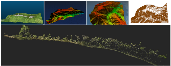
The output of LiDAR data acquisition is a dense collection of three-dimensional points known as a point cloud. This dataset represents the surface characteristics of the terrain and objects in high detail (Zhou et al., 2019).
From the point cloud data, several derivative products can be generated, such us:
- Digital Elevation Model (DEM), which depicts the ground surface
- Digital Surface Model (DSM), which includes objects above the surface
- Contour maps and slope models
- Cross-section: used to analyze changes in elevation along a route
One of the most important capabilities of LiDAR is its multiple return system, which allows a single laser pulse to produce several reflections from different surfaces such as vegetation layers and the ground. This enables accurate separation between ground and non-ground objects (Guo et al., 2010).
- The Role of LiDAR in Mineral Exploration
In mining exploration, LiDAR plays a crucial role in providing detailed and accurate topographic data. This data is used to identify landforms such as valleys and hills, as well as geological structures like faults, which can indicate the presence of minerals.
Research in Indonesia indicates that the use of LiDAR can improve the accuracy of elevation models compared to conventional methods, particularly in areas with complex terrain (Prasetyo et al., 2016). This demonstrates that LiDAR holds significant potential for enhancing the quality of mining exploration.
Additionally, LiDAR supports:
- Planning access roads and infrastructure
- Determining drilling locations
- Evaluating slope stability and geotechnical risks
In tropical environments, LiDAR is particularly effective due to its ability to penetrate vegetation. The multiple return mechanism ensures that ground elevation data can still be obtained beneath dense canopy cover (Meng et al., 2010).
Recent studies have shown that LiDAR significantly improves elevation accuracy compared to conventional methods, especially in complex terrains (Chen et al., 2017). This enhances the reliability of exploration analysis and decision-making.
- Advantages of LiDAR Over Conventional Methods
LiDAR offers several advantages over conventional surveying methods, namely:
- Fast data acquisition, covering large areas efficiently
- High accuracy, both horizontally and vertically (Zhou et al., 2019)
- Vegetation penetration, enabling ground detection in forested areas (Guo et al., 2010)
- 3D visualization, providing realistic terrain representation
- Multi-product outputs, including point cloud, DSM, DTM, contour maps, and cross-sections
These capabilities make LiDAR a powerful tool for improving the effectiveness and quality of mining exploration.
- Integration with Geographic Information Systems (GIS)
LiDAR data can be integrated with Geographic Information Systems (GIS) to enable advanced spatial analysis. This integration allows combining LiDAR-derived terrain data with geological maps, satellite imagery, and geochemical datasets.
Using GIS, LiDAR outputs such as DTM and contour maps can be used for:
- Prospect area modeling
- Terrain analysis
- Hazard and risk assessment
- Infrastructure planning
According to Weng (2012), integrating remote sensing data with GIS significantly enhances spatial decision-making processes.
- The Role of LiDAR in Mining Sustainability
In addition to exploration, LiDAR is also used for environmental monitoring in mining. The topographic data generated can be used to monitor land changes, evaluate environmental impacts, and plan post-mining reclamation.
Outputs such as DTM and cross-sectional profiles are particularly useful for:
- Monitoring land surface changes over time
- Identifying erosion and landslide risks
- Planning post-mining land reclamation
By utilizing LiDAR, mining companies can implement more effective environmental management strategies, supporting sustainable development goals (Chen et al., 2017).
- Conclusion
LiDAR is an effective technology for topographic surveying in mining exploration because it can generate fast, accurate, and detailed data. The LiDAR processing yields several key products, including point clouds as the primary 3D data, DSMs, DTMs, contour maps, and cross-sections, which support comprehensive topographic analysis.
The results indicate that LiDAR is capable of providing more comprehensive information than conventional methods, particularly in landform identification, slope analysis, and exploration planning. Through the integration of GIS and UAVs, LiDAR holds great potential for improving efficiency and supporting sustainable mining practices.
References
Prasetyo, Y., et al. (2016). Pemanfaatan LiDAR untuk ekstraksi DEM di wilayah tropis Indonesia.
Chen, Q., Gong, P., Baldocchi, D., & Xie, G. (2017). Filtering airborne LiDAR data for vegetation analysis. Remote Sensing of Environment.
Guo, Q., Li, W., Yu, H., & Alvarez, O. (2010). Effects of topographic variability on LiDAR-derived terrain models. ISPRS Journal of Photogrammetry and Remote Sensing.
Meng, X., Currit, N., & Zhao, K. (2010). Ground filtering algorithms for airborne LiDAR data: A review. Remote Sensing.
Zhou, T., Popescu, S., & Lawing, A. (2019). LiDAR remote sensing for terrain analysis. Remote Sensing.
Weng, Q. (2012). Remote sensing and GIS integration. McGraw-Hill.
Badan Informasi Geospasial. (2018). Spesifikasi teknis pemetaan dasar nasional.


Leave a Reply
Want to join the discussion?Feel free to contribute!